Monday, November 30, 2009

No Epic Thunderstorms but my house was slammed with epic north winds

The mid-level cold front did graze the island chain overnight, dumping snow on our two big volcanoes. The snow is visible this sunny morning, but the snow is pasted to only the north side of the mountains, something I have not seen before, but obviously due to the intense north winds. Besides the snow, some cold and very gusty winds whipped up around midnight for an hour and really slammed the north side of my home. Heavy rains were hitting the east side of the Big Island from Waipio to Cape Kumukahi. The east side of Maui also had serious rain, as did sever isolated locations on the other islands. But the cold trough is moving away quickly, soon to be replaced by yet another cold front from the north in a few days. Feels like winter.

Out on the active lava fields west of Kalapana there are no inland surface flows to be seen, only a line of pahoehoe sliding over cliffs into the sea. These flows are far away from the County viewing area. But the ongoing large ocean entry of lava at the Waikupanaha location continues and delighted many visitors last night. Lava pressures remain low but fairly steady as recorded by USGS deformation sensors.

CURRENT MOON

Sunday, November 29, 2009

Bench Collapse Limits Viewers Lava ~ Red Road Plume View

Some of the Waikupanaha ocean entry lava bench, the new land formed on the shoreline since the last large collapse on October 25th, has broken off. The outer tip was absent when geologist surveyed the delta Saturday morning. This break may have taken place without being witnessed, but what is witnessed now, as a result, is much less visible lava pouring off that new bench of land. Even so, spectators excitedly reported having seen molten lava pouring off the remaining sea cliffs.

Weather: As I reported yesterday, a fast-moving, north-arriving trough of cold air is moving over the Hawaiian Islands today through Monday. State forecasters are not expecting the “epic thunderstorms” they mentioned yesterday , but do have heavy rains with the possibility of thunderstorms in the forecast, followed later in the week by a full-on cold front Friday & Saturday… Yes we do have winter weather in Hawaii.

Photo of the Day: Ocean entry lava plume from the Red Road

Photo above was taken near Opihikao along the most beautiful road on the Big Island, Highway 137. 137 is known locally only as the Red Road because the original paved highway was made using a large amount of red volcanic cinder, which caused the pavement to actually look red. The Red Road was re-paved in recent years so all but a small section is now covered in black pavement. This new top coating has not changed its local name. Below is another picture from along the infamous Red Road, now paved black.

Saturday, November 28, 2009

Epic Thunderstorms for Hawaii?

Today the National Weather Service Forecast Office out of Honolulu issued their area forecast discussion for the state ,which reports, in part, a reference to a fast moving cold front approaching the islands from the north:

“If the cold pool follows the more southerly track favored by some (computer model) solutions, then some truly epic thunderstorms could develop around the state from Sunday afternoon into Monday morning.” --- sounds exciting! This disturbance is expected to move across and beyond the state rather quickly, retuning Hawaii to a normal Trade Wind situation by early next week.

The broad view of the northwest pacific water vapor loop shows this cold front pushing towards the island chain. (These satellite imagery loops open a little slow and also are constantly updating and therefore only correspond to my posts on the day posted)

Spectators who made the trek out the trail to the coastal viewing area are still reporting visual lava pouring off the ocean entry pali, as seen in the opening photo of this post from the 23rd. , and a strong plume that revealed an undulating orange-red glow after dark. The more distant, and most recent ocean entry points to the west of Waikupanaha have slowed down their volume of lava reaching the sea. I could not see any surface flows or hot spots across the coastal plains or mauka (inland).

... Speaking of epic, surf on some of the islands north shores was huge this past week, as this video of Waimea Bay on November 25th shows.

Friday, November 27, 2009

Hot Lava Rocks Float


Pictured above is a typical newly forming lava bench at the Waikupanaha ocean entry location. If you look along the waters edge of the bench (click on the image for a larger size) you will see chunks of molten lava being picked up by the incoming waves and carried out; floating and steaming into the ocean. These floating rocks are still molten inside until they cool completely, at which time the will sink.


The next two photos below show these floating rocks, and some of the stones are still showing molten red even though they are in the sea.


Some of these hot floating rocks will be washed onto shore. The photo below shows some of them on a new black sand beach near to an ocean entry location.


The US Geological Services deformation image for today shows that the overall trend in magma pressure under Kilauea Volcano remains fairly strong and steady, which could translate into continued lava pressure throughout the network of molten lava plumbing carrying lava from the Pu`u area eruption site all the way down to the two main Waikupanaha ocean entry points. This should keep visual shows of lava on the exciting side for visitors to the Counties viewing area near Kalapana.

Thursday, November 26, 2009

Mahalo Nui For Blessings

A dentist’s chair is not where I wanted to be yesterday when I usually write these blog updates … Teeth trouble is one of my biggest personal peeves! I will have difficulty enjoying any home-cooked Thanksgiving foods but the friends I will be sharing that with will be special. I can still count many blessings.

Pele continues dazzling locals and visitors out at the Waikupanaha ocean entry off the lava-severed Kalapana end of highway 130. A weather disturbance is sweeping close to the islands and caused flash flooding on Kauai this morning and very large north ocean swells the past two days. Here on the southeast side of the Big Island we have mostly cloudy skies, gusty cool winds and occasional rain showers.

Have a wonderful day,
Leigh

Tuesday, November 24, 2009

Pele's Palette of Cooled Creations

Today I will offer some of my photo collection of cooled or cooling pahoehoe formations (click on any imag for a bitof a larger view size). As for the current lava flow along the coast, it is continuing to delight spectators with lava flowing off cliffs along the edge of the huge ocean entry plume. Dry weather and having a smile-faced moon sitting with the planet Jupiter is a plus :)


Monday, November 23, 2009

Molten lava flowing off ocean entry delta - Video clip of Halema`uma`u explosion

Spectators who hiked out to the County lava viewing area are still being able to see lava flowing off cliffs and into the ocean. One woman reported watching a large portion of the sea cliff fall away and produce some explosions. Through binoculars or long camera lenses viewers there see scenes like the one below:


As the US Geological Survey deformation graph below reflects, a drop in magma pressure has been occurring the past three days, yet active lava viewing remains pretty good.


Dramatic video of an explosive event within the Halema`uma`u crater November 21st, 2009:

Quote by the geologists: “This Quicktime movie (at x2 speed) shows a small explosive event in the Halema`uma`u vent at 9:20am. The explosion was immediately preceded by a portion of the vent rim collapsing into the vent cavity. The brown plume rises rapidly from the vent, and in the full resolution video large particles can be seen ejected in front of the plume. In the video shown here, it is possible to see some of these particles impact the crater wall—look for several small white puffs to appear on the crater wall just ahead of the rising brown plume (about 7-9 seconds into the video clip”

Sunday, November 22, 2009

Rebuilding Kalapana – Eighteen years later


Pictured above is a new house being built on open lava fields that once were the infamous Kalapana Gardens. In the background lava pours forcefully into the sea. Many new homes have been springing up across what once was a most beautiful part of Hawaii’s Big Island: Kalapana, Kaimu and vicinity. Pictured below is one of the homes at the same location being destroyed by lava on April 22nd, 1990.


Beginning as early as 1986 a new branch of lava began bringing lava closer and closer to this piece of Hawaii paradise. But it was in the year 1990 that much of the area was overridden by lava and destroyed. I will not give more history in this post because it has been documented so well by others. On this link the USGS has offered a very good history of the destruction by lava of Kalapana with great photos.

In 2005 Kalapana Gardens was resurveyed to relocate original property lines and soon after a few people returned to reclaim their property. Some sold, others built.

Meanwhile just a couple of miles away, as the top photo shows, lava continues flowing very close by this new construction. The new homes do have a dangerously grand view of the ongoing lava activity: a line of fumes mark the underground and surface flows covering many miles from the eruption zone on the mountain and a nearly mile-wide swath to the sea; entering the ocean in two locations.

Visitors to the active lava viewing area were excited last night as they watched from a distance lava pouring into the sea. A sweet crescent moon hangs above the lava plume after dark and also the planet Jupiter.

Thursday, November 19, 2009

Hawaiian Lava Daily down due to search engines being blocked

Some kind of computer invasion has shut down all my search engine capabilities. This means I cannot log-on to my Gmail account to post my daily blog here. I am on a borrowed computer to let my readers know why I could not post yesterday and that I am working on the problem today. I will return as soon as I resolve the issue.

While I am here I might as well report that lava activity is pretty strong down on the coast: ocean entry lava was powerful and viewers were even able to see lava pouring off a small cliff and into the sea. There were also a few bright orange-red surface breakouts visible after dark.

Tuesday, November 17, 2009

Two main lava types ~ And a nice ocean entry display continues


Two types of lava flows, pahoehoe and a`a, are different textural forms of otherwise identical lava. The smooth-textured pahoehoe (foreground) are formed by gas-poor lava, whereas the sharp & jagged-surfaced a`a flows (the hot lava pictured) are produced during eruptions with lava coming out of gas-rich magma. Eruptions of a`a lava commonly evolve into the pahoehoe forms.


The majority of lava between the eruption site up on the mountain near Pu`u O`o crater and the ocean 6 ½ miles below are of the pahoehoe variety. But interspersed along that zone are sections of a`a that are usually avoided while hiking the terrain because a`a is very sharp and unstable; breaking underfoot like sheets of glass and just as sharp.


The photo below was my creative attempt at making an a`a sheet look not so menacing. The stars of light is the sun shinning through some puka’s (holes).


Current lava flow conditions:

Last night out off the end of the road, at the County lava viewing area, Waikupanaha ocean entry was going strong to the delight of hundreds of spectators. Surface flows, on the other hand, were quite subdued. But by 9:00 PM we began seeing some bright spots of molten lava randomly appearing across the coastal flats, as well as inland upslope locations.


The increasing surface flow sightings correspond well with the continuing up-tic of lava pressure being recorded under Kilauea Volcano, as mentioned in yesterdays posting.

Monday, November 16, 2009

New Moon = More lava ?

CURRENT MOON


Perhaps the new moon had something to do with it – lava pressure is returning to the miles and miles of molten rock plumbing system: the labyrinth of underground arteries feeding all visible lava on the mountain and gong into the ocean. I will not attempt to delve into this moon-lava pressure theory deeply here –hehe - but the longer up tick on the deformation graph below indicates a strong change – finally.
We hope this translates into more visual activity of lava, both on the surface across the broad flow fields and at the two coastal ocean entries.

I was out there last night, the end of highway 130 and the Hawaii County viewing area, and the closer ocean entry lava show was going pretty good. A few fireworks of tephra-sparks soared out after dark. There was no visible surface lava to be seen inland from there. But with this increasing pressure of lava coming on, perhaps tonight we will witness some brighter activity there.

Sunday, November 15, 2009

Hawaii drying out ~ Heavy rains did not stop lava flow

My next door neighbor Mike’s rain gauge is the official kind and he checks it daily at 7:30 AM. He phoned me at 2:00 PM yesterday to report 11-inches of rain had fallen since 7:30 AM. The thunder-lightning blasts were fun too... At their height, Mike phoned to report our neighbor's house might have been hit by one large bolt... But it turns out it missed by a few feet.

Inland is still wet but the northern low-pressure winter storm is pulling apart and away fro the Hawaiian Islands. Trade winds are coming back in but still carry a lot of moisture.

If it is dry enough later today I will finally venture out of the house and go check out the lava activity at Kalapana’s Waikupanaha ocean entry and flow fields.


As reflected in the USGS ‘deformation’ pictured graph above, magma pressures in the massive reservoirs under the Kilauea Caldera have been all over the place this past week and that has affected lava flow; increasing and decreasing active lava coming down the mountain and into the sea. If I can, I will go get a firsthand account for you tonight.

… Now I am off to repair my carport that collapsed from the severe rainstorm….

Saturday, November 14, 2009

When we thought it couldn’t get wetter


For details on the above image click on National Weather Service updates

Extremely heavy rains are coming down here at Cape Kumukahi, Hawaii’s most easterly point of land. My photo of the heavy rains off my lanai yesterday looks like a sprinkle compared with this mornings drenching.

Thunder & lightning have been striking the earth very close by my house. Gusty winds are driving the rains. My neighbor Mike, who is the local rainfall reporter phoned saying we had over three-inches overnight and are now receiving more than an inch of rain per hour.


This reporter will not have any lava flow updates today, but if by some chance this clear by midday, he may venture out to the active lava flows…

If you are reading this at posting time you will be able to see the rains over the southeast side of the Big Island here: NWS radar image loop

Friday, November 13, 2009

Rain and More Rain


This photo above (click on it for larger size), taken minutes ago, pretty much sums-up the weather on the east and southeast shores of the Big Island for the last twenty-four hours. The same can be said for most inland areas and portions of all the Hawaiian Islands.

Serious rain and thunderstorms along with strong winds and very rough seas have been smacking the Hawaiian Island chain and causing locals and visitors to make new plans. The cold air associated with the northern low-pressure system has me typing this wearing slippers – not slippahs - furry winter slippers, a long sleeved shirt & pants--- it’s cold!

National Weather Service Honolulu continues flood watches and warning throughout the State, with the Big Island and Kauai to be getting the most rain today and tonight.
This Central Pacific Water Vapor Loop nicely shows the atmospheric mess the islands are currently sitting in.

Below is this mornings infrared imagery; the yellow-orange areas being very wet - so wet around the Big Island it is hard to spot it within the image:


A small amount of snow fell on the two volcano tops overnight and the road to the summits is presently closed to public traffic. You can look at the Mauna Kea Webcams to see conditions up there..

Lava viewing area was closed again yesterday and may likely not open tonight either. Again, phone the hotline after 2:00PM to find out for sure: 961-6028

Thursday, November 12, 2009

Northern-Low Weather Threat Continues ~ Lava Deflation

Without sounding too repetitive with these posts regarding weather I do so because climate conditions in Hawaii affect such a broad number of our activities here: from the drive to & from work, plans to play on the other side of an island, surfing, lava viewing and most other outdoor activities - even snowboarding!. That said…

Official Hawaii weather forecasters continue posting advisories ranging from high surf, high winds, snow on the volcano summits, thunderstorms, and heavy rains with flood watches for all the Hawaiian Islands.

An ongoing push of a massive northern low-pressure system creates unstable and variable weather in the region. Unstable means the mix of rotating upper level cold air with warm moist ocean surface air can produce quickly shifting winds and surf conditions, rapidly developing thunder storm cells and difficulty predicting exactly when & where these will develop over each island. This instability will continue until this northern low moves off the islands, which should begin in the next few days.

Currently, here on the east point of Hawaii Island it is overcast with
numerous showers, calm - muggy air and some nice surfing swells rolling in.


Lava Activity:

Some serious deflation of lava pressures is taking place on the heals of a zigzag week of lower pressure. The US Geological Service graph below plots this. Generally a lower deflation (drop in magma pressure under the Kilauea Volcano) produces a decrease in lava activity visually seen between mountain and sea.


As my 2:00PM alert posted yesterday said, the County viewing area was closed at that time due to southerly winds pushing the toxic plume fumes back over where visitors would gather to witness the ocean entry lava at Waikupanaha. I would suggest phoning the Lava Viewing Civil Defense Hotline at 961-8093 at around 2:00 PM or after for today’s update. If you are making plans to visit Hawaii Volcanoes National Park you can phone for information at 985-6000

Wednesday, November 11, 2009

No Snow – Little Heavy Rain –But The Air Feels Ominous - Rainbow Weather

EDIT NOTICE - 2:00 PM Wednesday the 11th. 2009-- The Civil Defense Lava Viewing area will be closed today due to unfavorable wind directions that are causing the ocean entry toxic fumes to lie back over the viewing area.

Early this morning I could see the top of Mauna Kea – still snowless even as it’s name means White Mountain in Hawaiian. Official forecasters are still warning of very strong winds and possible heavy snow up there. A large counter-clockwise spiraling low-pressure system pushing down over the Hawaiian Islands from the north, whose center now lies close to Kauai, remains almost stationary. This low contains lots of upper level cold air. The cold air creates troughs that suck heavy, warm, moist air in from the south of us. It is this mix that can create large thunderheads and dump heavy rain on the islands, or snow on the tops of our two highest volcanoes – and – create heavy rain clouds out of what were only minutes before, clear blue skies.

By complete chance, this is exactly what is happening as I type!— mostly clear blue skies were predominant as I looked out in all directions from my little weather-tower of a house less than twenty minutes ago… Suddenly, starting from mauka side, the sky thickened with darkening purple-black clouds and began pouring rain while the morning sun continued shinning from the side…. I must be inside a rainbow right now!! Have you ever been inside? Sometimes you can actually see the sparkling iridescent mist drops of colors shimmering in the air all around you. While we’re on the subject, did you know that with a double rainbow the color patterns are mirrored/reversed from each other?


Lava Flow:
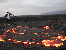
I was not out there to witness the lava activity first hand this time, but my reporters stated that the previously visible surface flows of lava could not easily be spotted out on the active flow fields to the west of County viewing areas. They also reported a weakened ocean entry activity at Waikupanaha, but it was still billowing up a steam plume and glowing lava colors after dark

The weaker lava activity can likely but attributed to a continuing drop in magma pressure under the volcano, as registered on USGS sensors and as shown on the graph below. The up & down pressure has been stuck in that pattern for six straight days, which is fairly unusual.


Friends have been reporting some decent surf sessions on our southeast shores…. I’m missing out; been too busy to make it out there… Geez, I can even hear a nice surf pounding in right now!

Tuesday, November 10, 2009

Hawaii Island Feels Wet & Heavy -- Severe Weather Flash Flood Watch – Blowing Snow?

Skies darkened deeper yesterday with each passing hour here on Hawaii Island’s most easterly point; Cape Kumukahi, Kapoho. Heavy rains soon followed, continuing most of the night. This morning, though, it is not presently raining along the coast but again sprawling dark masses of rain clouds hover offshore as forecasters continue calling for increasing rains tonight through Thursday night. A Flood Watch remains for all Hawaiian Islands through Thursday night. Thunderstorms possible. The radar image below of the Hawaii Islands shows a satellite's view of the dark offshore cloud I am now looking at out my window:
You can watch the updated radar image loop for just the Big Island on this link.

Summits of our two volcano monoliths – Mauna Loa and Mauna Kea - have severe winter weather storm watches posted, with possible heavy & wind-blown snow accumulations. Clouds currently shroud these mountain tops but Mauna Kea Webcams reveal no snow accumulated overnight. Save the link to these cams and check them tomorrow morning for signs of overnight snowfalls.

Lava Flow Conditions:
Cloudy skies have lifted high enough that I can see the ocean entry lava plume billowing up strongly from my upper lanai – eighteen miles distant. Despite continued fluctuations of weakened magma pressure within Kilauea Volcano, as reflected by today’s deformation graphs , lava continues to advance as hotspots across the coastal lava fields and ocean entries.

The heavy rains may hinder viewing or even close the County Lava Viewing area so it might be a good idea to phone the Civil Defense Hotline at 961-8093 before heading out there. They update that information around 2:00 PM seven days per week. Viewing hours are from 5:00 PM to 10:00 PM (but usually close closer to (9:30 PM)

Monday, November 9, 2009

Magma Pressure Three-Day Low Affects Viewing ~ Weather Alert For Hawaii


Tiltmeter sensors based at Halema`uma`u and Pu`u O`o craters recorded three days of very up & down fluctuation in magma pressures; all on the low-pressure side. This has translated throughout the lava tube plumbing and surface flows as a lessening of visible activity: less molten lava surface breakouts, a weaker ocean entry plume. The graphing now indicates an up tic in pressure for the last 24 hours. If that trend continues we may once again be seeing more surface activity tonight.

Last night at the Waikupanaha ocean entry, even though the steam plume was not as strong as it has been this past month, visitors reported and recorded on their cameras something not often seen from the viewing area: molten lava rivers running off the shoreline pali and into the sea.

Molten lava continues reaching the West-Waikupanaha ocean entry and is covering the last remnants of a long-standing blacksand beach as the photo below documents:


~
WEATHER:
From the National Weather Service Forecast Office – Honolulu “HYDROLOGIC OUTLOOK NATIONAL WEATHER SERVICE HONOLULU HI 340 AM HST MON NOV 9 2009
...THE NATIONAL WEATHER SERVICE IN HONOLULU HAS ISSUED A FLOOD POTENTIAL OUTLOOK FOR THE STATE OF HAWAII... LOCALLY HEAVY RAINS AND FLASH FLOODING POSSIBLE WEDNESDAY AND
THURSDAY... AN UPPER LEVEL LOW IS FORECAST TO MOVE OVER THE ISLANDS WEDNESDAY AND THURSDAY AND BRING SOME UNSETTLED WEATHER THAT INCLUDE THE CHANCE OF HEAVY RAINFALL AND FLASH FLOODING.”
Click on this Central Pacific Water Vapor Loop to see the northern low pressure system that is pushing unstable cool air over the Hawaiian Islands.

Sunday, November 8, 2009

Vortex Plume Twisters


Looking very much like water spouts, and often miss-named that way in many field reports in the past, these ‘plume twisters’, as I call them, are actually spinning columns of steam sucked out of the super-heated vortex of broiling plume steam.

As lava pours into the ocean the resulting collision produces all sorts of chemical and geological reactions such as sulfur dioxide, hydrochloric acid, ash, tephra, black sand, an assortment of glass particles, several other gases and lots of extremely hot steam. As the steam races rapidly upward the relatively colder water and air surrounding it tends to pull at the edges of the plumes rolling steam – stretching it out and producing these fingers and columns of spinning steam. There is no technical name for this phenomenon that applies exclusively to lava- generated plume steam. The closest proper descriptive is Steam Devil, or steam vortexes: “a rotating updraft that involves steam”.


Or maybe it is time we gave this unique phenomenon a local or Hawaiian name…. How about Niniu hawai ? In Hawaiian Niniu means ‘spinning, whirling’ and hawai means ‘steam, breath of water’…. Or maybe simply: Pele Devils :)

I have witnessed these steam vortexes separate from the plume and float off on the prevailing air currents, still rapidly rotating, and carrying on for a half-mile before dissipating into mist and disappearing. Below is a very unusual steam devil that separated off of the lava entry plume curving back onto itself to form a ring:

Saturday, November 7, 2009

Aerial Overview Photos with Text Oct 29th & Nov 6th, 2009

By comparing the two USGS aerial photographs below, even though they were taken from different perspectives, we can see the progress of the active surface flows of lava in the past week. I have added some text to both images that point out key points of interest. By clicking on the photos you can open a larger image size.
The top image is the most recent - November 6th, 2009


Below - October 29th, 2009


Weather wise, the mass of unstable moisture that was hanging heavily just west of the Hawaiian Islands had weakened and does not pose much of a threat now.

Friday, November 6, 2009

Deflation Affects Surface Lava ~ Photos of New Ocean Entry

Deflation of magma pressure, which began just after midnight on the 5th, did produce a cooling down of visible surface flows of lava across the coastal plain by afternoon, but did not stop it. Summit tiltmeter graphs recorded inflation returned at 4 pm yesterday afternoon and by evenening, red-hot glowing mounds of pahoehoe were once again getting brighter; by 9:30 PM were looking like little volcanoes themselves - yellow tops and with flowing rivers of red and orange down their sides.

~


As shown in the photos above & below, taken by USGS photographers November 4th, lava is entering the ocean 2300-feet to the west of Waikupanaha.
Waikupanaha's large ocean entry to the east of here remains strong.


.
Lava field geologists reported that surface flows closest to the viewing area trailhead had slowed way down but were still threatening kipuka forest remnants nearby

~


~

Central Pacific Water Vapor Loop satellite imagery of the massive weather system just west –northwest of the Hawaiian Islands is remarkably locked into the same position as yesterday, which holds off the heavy rain a few hundred miles due west.

The National Weather Service forecasters in Oahu are still uncommitted as to the affects of this system, though most computer models indicate some unstable weather over the islands later into next week.

Thursday, November 5, 2009

Large Wet Storm Churns Close to Islands ~ Lava Spreads out on Coastal Plains


Lava continues to flow across coastal plains west of county viewing areas as shown above. Some kipuka vegetation remains and is being burned out and covered as pictured below.


Three ocean entry locations pour lava into the sea: two side by side at the usual Waikupanaha tube-fed location, and the newly formed surface flow further west 2000-feet or so.


A serious drop in recorded ‘deformation’ on Kilauea crater tiltmeters began at 1:30 AM and will likely be reflected by a substantial reduction of surface lava on the coastal plains in the next day or two, and possibly affect the Waikupanaha ocean entry as well.


Our first sizable cold front from the north has arrived close enough to produce this weeks large north-facing ocean swells, and carries an impressive amount of moisture churning within. This large low-pressure system is only a few hundred miles to the west-northwest of the Hawaiian Islands right now, and official forecasts are unsure if the islands will get the heavy rains, but if we do, the rains could arrive by early next week. This storm will likely cut off our Trade Winds as well, and we all know how we feel about that. This Central Pacific Water Vapor Loop currently shows this northern low pressure system in action, as it looks today (takes a bit of time to load but looks pretty impressive at the moment).