

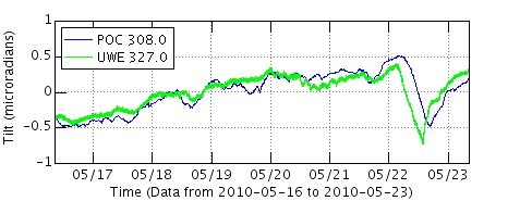
As shown in the images above, within hours of deflation being recorded by USGS deformation tilt monitors, Halema’uma’u’s now infamous billowing sulfur dioxide plume turned into a wisp of its former self yesterday, as shown in a comparison of two saved image off their crater cams.
Hawaii Volcano Observatory’s (HVO) Status Page for today gave a nice detailed report of yesterday’s Halema’uma’u event; an excerpt here:
"Past 24 hours at Kilauea summit: Three times yesterday, lava rose in the deep pit inset within the floor of Halema`uma`u Crater before abruptly falling to its previous level. The first started rising at around 10:20 am and stayed high until 12:20 pm, the second event was from 2:45 to just after 4 pm, and the third from 7:25 to nearly 8:30 pm. Each high stand was shorter than the previous one and lava rose several meters higher during the second event than during the first and third. The gas plume from the vent went wispy during at least the first two high stands. The change in lava level during a similar event on May 18 was estimated to be about 20 m (66 ft). Each of the three events was accompanied by a large decrease in seismic tremor and a small increase in ground tilt toward the vent; each geophysical measure resumed its previous values after the lava level fell to previous levels.
Between these events, the 60 by 90 m (200 X 300 ft) crusted, circulating, bubbling lava pond at the bottom of the deep collapse pit on the southeast edge of Halema`uma`u Crater, remained fairly stable; the surface appeared as bright jagged lines between slowly drifting crustal plates; bubbling was mostly concentrated at the southern (webcam left) edge where the lava sank out of sight. When weather permitted, glow from the vent was easily visible from the Overlook and in the HVO webcam overnight."
Below are my reports from May 22, as well as previous posts, which continue to reflect the present situation as far as coastal activity with the ongoing lava:
~~~~~~~~~~~~~~~~~~~~~~~~~~~~~~~~~~~~~~~~~~~~~~~~
Lava flow strong and stable from the pali into the sea
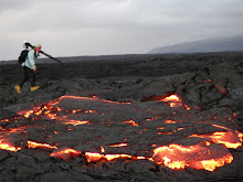
 Ocean entry May 22, 2010: photographer on the distant left is in a very dangerous location perched on top of the unstable leading edge of the actively forming bench, and in the distant right, a tour boat disapears into the toxic fumes.
(May 22nd:) There are currently no active surface flows between the scattered pali breakouts and the ocean. The plumbing system for this April-May eruption is establishing into two main lava tubes with underground branches along the coast. There are several large ocean entry points of lava and numerous smaller ones; spanning about a half-mile of newly forming shoreline. A few spots of burning vegetation continue along the flow fields.
Coastal lava viewing area news: Hawaii County still have not relocated the visitor parking back down to the terminus of highway 130 as rumor said they would be doing. There is no danger to the public that I can discern by allowing the 600 to 800 visitors currently arriving daily to see some warm lava a little closer to them and not having to walk a mile to do so. The park and walk-in situation is getting ridicules in my opinion, though some people report they actually enjoy the scenic lava forms and views of the ocean entry plume and nighttime glow, and the pali fumes as seen along the end of highway 130.
----------------------------------------------------------------------------------
May 19-to May 22:) As I have been doing lately, I will repost recent blog reports as they remain reflective of the current situation:
 May 5th lava onto highway
 Looking northeast -the end of highway 130 can be seen in the top middle of the image. Hawaii County is considering a new viewing area on this section of the still-cooling lava. From that vantage point visitors would have a better view of both the ocean entry plume and the visible spots of lava coming down the pali; as well as the vast acreage of fuming lava fields to the west and south. But for now they are planning to at least move the parking and road-end viewing back to this end of the road – eliminating that mile-long hike there & back. This parking relocation may take place today or tomorrow (This has not yet taken place days later!).
----------------------------------------------------------------------------------
Below is a reposting of the general overview of conditions on the coast since little has changed in (five) days:
Halema’uma’u Crater still glowing brightly ~ Lava flows hot from mountain to sea

US Geological Service (USGS) at Hawaii Volcanoes National Park Observatory (HVO) has posted this excellent aerial photo over crater (above) on their images page. On that page they also have photos and captions about the Pu`u O`o crater cam they lost when a piece of the crater sloughed off a few days ago.
 (Click on it for a larger view size in a new window)
The aerial photo is from the April 28th, 2010 USGS image site, and surface lava has advanced further in many areas since, as indicated on my drawings and notes.
 Halema’uma’u crater as seen after dark from the balcony of the Jaggar Museum
Active lava viewing prospects:
1) The Halema’uma’u crater has been degassing sulfur dioxide fumes by day and glowing strongly at times after dark from lava deep within the craters pit vent. Great views are from the Jaggar Museum within the Hawaii Volcanoes National Park, and the park is open to the public 24 hours a day.
2) Coastal viewing:
Highway 130 at Kalapana Gardens area -- Between the hours of 2:00 PM and 8:00 PM - park and walk one mile to the end of newly lava covered (May 5th) road; viewing is allowed until about 9:00 PM. Along the walk out and back the steam plume from the distant ocean entry lava can be seen and after dark it glows orange-red; long lines of degassing lava fumes coming down the hillsides by day –distant red lava orbs lined-up by night; at roads end the still-warm lava on the road can be felt and is still radiating hotter close by but beyond public access; occasional yellow flare-ups are witnessed in the distance as lava torches trees and vegetation further into the active flow field. Offered at the parking area only: security personnel, vendors, water and port-o-potties available; at roads end there are barricades, port-o-potties and security personnel.
USGS lava flow map gives a good indication of the active lava zones:

~~~~~~~~~~~~~~~~~~~~~~~~~~~~~~~~~~~~~~~~~~~~~~~~~~~~~~~~~~~~~~~~
Further information, links and warnings:
Active pahoehoe breakouts continue along with swelling of the hot flow fields at many locations of the April-May surface flow. The coastal entry points are still emptying a lot of lava into the sea as new deltas area being rapidly built. The entire length of the ocean entry and all land adjacent to it inland is quickly becoming unstable and should be kept well aware of from now on:
HAZARD ALERT: The lava delta and adjacent areas both inland and out to sea are some of the most hazardous areas on the flow field. Frequent delta/bench collapses give little warning, can produce hot rock falls out to 400 m (quarter mile) inland and in the adjacent ocean, and can produce large local waves and scalding water. The steam plume produced by lava entering the ocean contains fine lava fragments and an assortment of acid droplets that can be harmful to your health. The rapidly changing conditions near the ocean entry have been responsible for many injuries and a few deaths.
Below is the timeline links to my posts for this April-May flow:
You can watch the May 5th feature Hawaii-News-Now story of the lava coming onto the end of highway 130 by clicking this link here
Click on this link for a complete blog summary of this entire April, 2010 surface flow of lava; from mountain to sea: (scroll to the bottom and read each post running up for a chronological timeline)
And my most recent days postings for May, 2010
I will keep this as my main posting update layout in the coming days, adding new headings and images as lava events warrant.


No comments:
Post a Comment